
By Marie Orttenburger
Illustrations by Spencer High
On a warm day in May, dendrochronologists Michael Stambaugh and Daniel Dey visit Michigan’s Lower Peninsula to collect samples of red pine stumps to learn about fire.
They’ve traveled to a site just west of Wellston—a town whose own website warns that if you blink while driving down M-55, you might just miss it. The small unincorporated community’s point of pride is its location at the heart of the Manistee National Forest and proximity to the Manistee, Pine and Pere Marquette rivers, where anglers flock to fish for trout.
A turn down a sandy two-track leads into a sun-dappled forest where Stambaugh and Dey have parked their rented SUV. The research site is densely packed with towering red pines—their distribution betraying the mechanical, uniform way the Civilian Conservation Corps planted them after the U.S. Forest Service acquired the land in 1938. The nearly homogenous forest emits a pinkish glow thanks to the ruddy bark of the pines. Birds sing in the overstory, butterflies flutter along the forest floor. Most of the standing trees are likely less than 100 years old.
“We might look at this forest today and think ‘Oh, well it’s always looked like this,’” Stambaugh said. “Well, no, actually this is a planted forest. Then you see historical pictures, when everything was cut. What was it before that?”
That question can be answered, in part, thanks to General Land Office surveys conducted around 1800. Before it was logged, this research site was a mix of red pine-white pine forest, cedar swamp and white pine-mixed hardwood forest, according to a map put together by the Michigan Natural Features Inventory.
To go back further in time, researchers depend in part on nature’s record keepers: trees, soil, lake core sediment samples. These resources help answer questions about the composition of Michigan’s ecosystems before a deluge of European settlers arrived and clearcut the state’s ancient forests and turned its prairies into farm fields. This knowledge could help today’s land managers understand what they need to do to restore the land’s health and biodiversity.
Some of the answers may yet linger in this heavily altered forest.
. . .
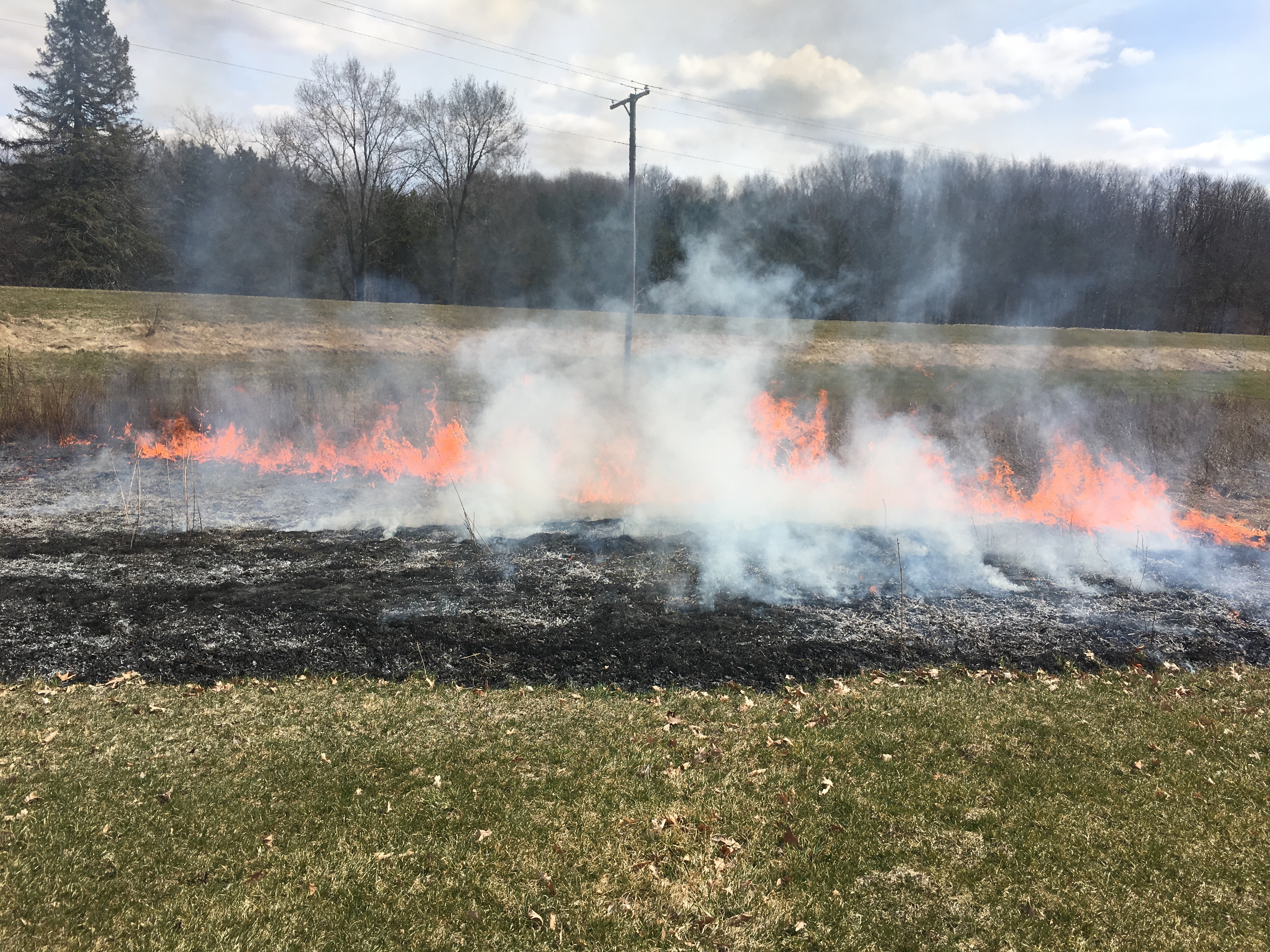
The Manistee National Forest was created from tax-forfeited and purchased lands that European settlers logged and then found unsuitable for agriculture. All that was left on the land was slash—woody debris that readily burned—and intense wildfires repeatedly took out any new growth that might have emerged. Trees didn’t regrow for decades following the land’s exploitation. Efforts by the Civilian Conservation Corps were ultimately what reforested the landscape. The red pines they methodically planted in straight rows still grow tall today and can be seen in every one of Michigan’s national forests.
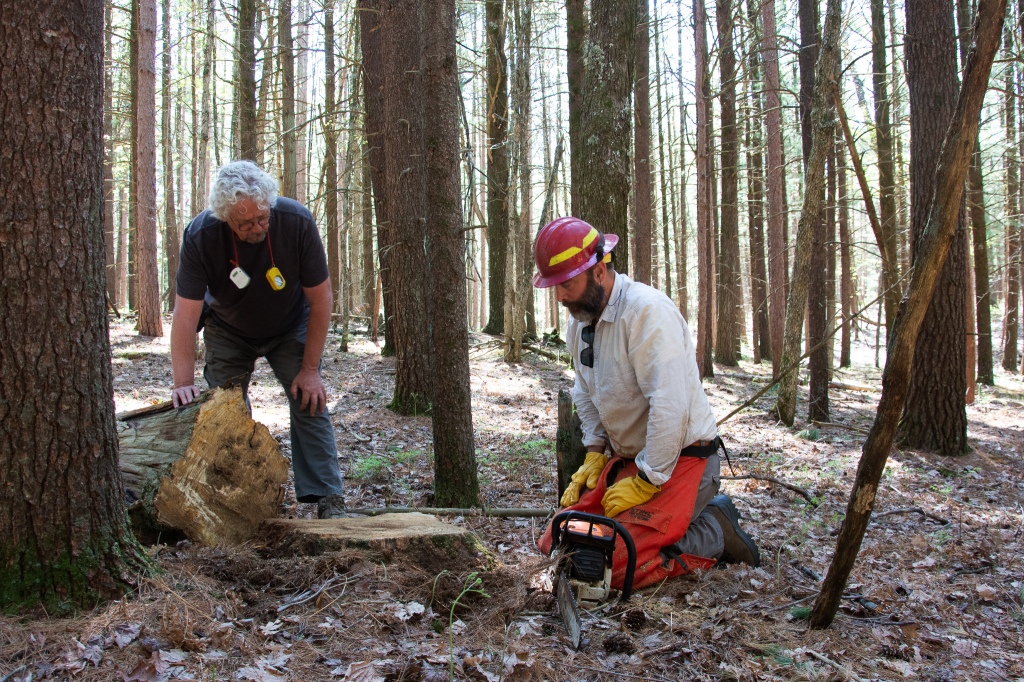
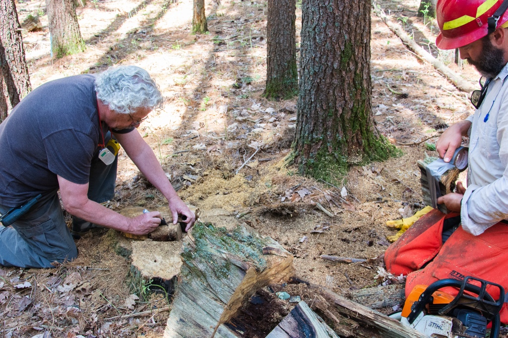
Stambaugh, Dey and their colleagues Richard Guyette and Joe Marschall are using dendrochronology—or tree-ring dating—to understand the Manistee National Forest’s historical fire regimes, or how frequently and intensely fires used to occur. To do this, they collect red pine samples—but not from those trees planted by the Civilian Conservation Corps.
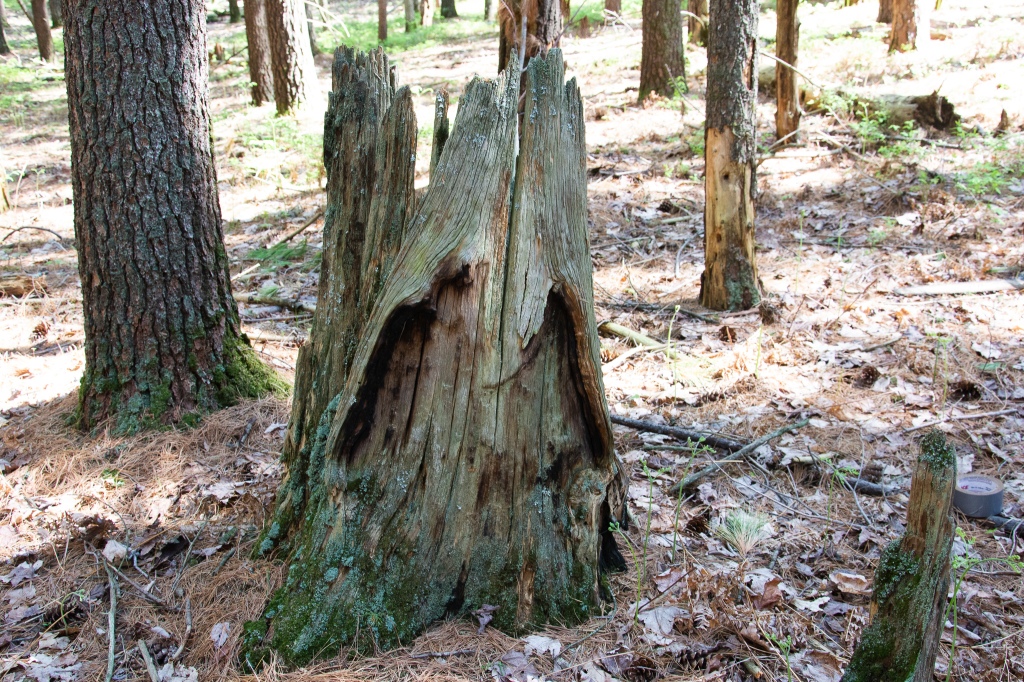
Training an eye along the forest floor at the Wellston research site reveals a few scattered “snags” between the rows of pines. These are the remains of long-dead, uncut trees—ones that died before the loggers arrived and were left to continue decaying.
“It’s like the prior forest is still here as a ghost, in some ways,” Stambaugh said.
These snags are what Stambaugh and Dey are searching for. They hold the most promise for data that spans far enough back in time to tell them something about the area’s early fire history. At a nearby site, Guyette found snags with fire scar dates as far back as 1717.
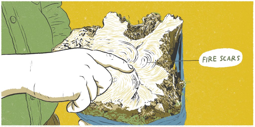
Hard pines, like red pine, are particularly well-suited to recording fire. These trees possess a unique defense mechanism: they produce resin in response to certain stressors. When a fire passes by the base of the tree, a heat vortex forms on the side toward which the fire is heading. Like a rock in a river with an eddy behind it, the passing flame flares up in that vortex and scars the tree. For other species, the scar would leave the tree vulnerable to infection by fungi, which would rot the wood and erase the data. Red pines instead secrete a resin that seals the wound and preserves the wood. The tree continues growing around the scar, the succeeding rings creating a pattern that scallops with each injury. The result is a record of every time a fire burned hot enough to damage the tree.
There are enough snags that Stambaugh posits that a “stand-replacing” fire—a high-intensity fire killing all or most of the trees in a given area—took out these trees. The accuracy of his hypothesis will be clarified once all of the samples are returned to the Missouri Tree-Ring Laboratory at the University of Missouri in Columbia and their rings are measured against master tree-ring chronologies. The relative sizes of the rings will illuminate where on history’s timeline those trees spent their lifetimes, as well as assign a year to every fire scar in a given sample.
Not every snag meets the criteria needed to warrant its collection. These trees have been decaying for decades—many are missing key parts of the timeline. Stambaugh passes by one snag, about three feet high, and peers inside. The center is completely rotted out.
“It’s probably one in 20 that we can actually get to the information,” Stambaugh said. “What’s gone is the earlier history, and that’s the sweet stuff.”
Once the researchers find a snag that appears to still have its integrity, Stambaugh revs up the chainsaw. He carefully saws several inches above the base of the snag, and then brushes away the sawdust to get an initial look at what its rings show. The roar of the motor quiets and an aromatic mix of chainsaw exhaust and pine sap lingers in the air. Stambaugh wraps duct tape around the perimeter of the stump to keep it together, then saws a few inches further down to extract the cross section.
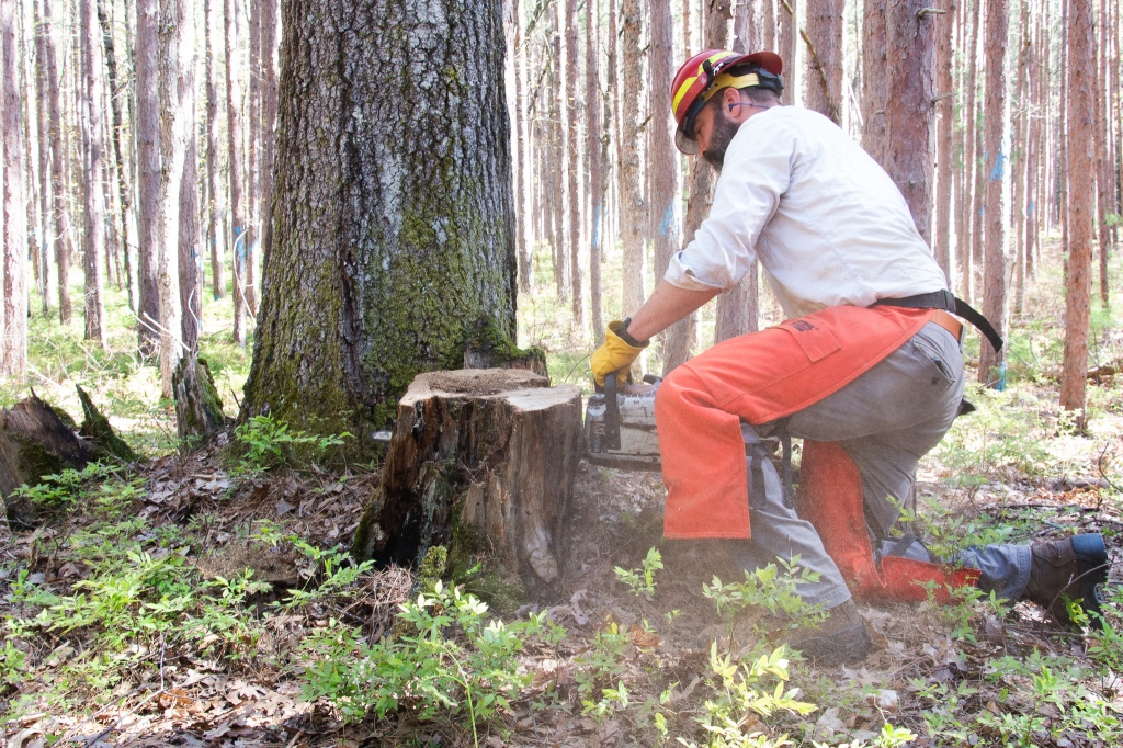
“We just try to take them apart slowly because they’re kind of fragile,” Stambaugh said. “We treat them as artifacts.”
Dey is the scribe of the duo, and in large black permanent marker he denotes details about the sample right on the stump: the date, the site name and sample number, the north- and south-facing sides, how far above the ground the sample was positioned and the degree of slope, if any. When the samples return to the lab, those analyzing them will know exactly how they sat on the land.
. . .
Fire used to be a much more common occurrence in many of North America’s ecosystems. Set aflame by either lightning or people, prairies, savannas, forests and even wetlands burned with varying degrees of intensity for millennia. In the last century and a half, however, Americans have adopted a culture of fire suppression—a mindset instilled with the establishment of the Forest Service to protect valuable timber and the cities and homes that developed with an exploding population. Now, ecosystems that used to burn every couple of years haven’t seen a spark in decades, and that has dramatically changed the way they look and function.
“There was a lot, a lot of fire—very frequent fire—in almost all systems. And we’ve lost that,” said Jack McGowan-Stinski, program manager for the Lake States Fire Consortium.“It’s a combination of the typical fire suppression that we think of, where when a fire started, it was put out. It’s a lot more than that. It’s also lack of ignition, and it’s cultural suppression, because Indigenous peoples used fires, it was one of the tools they had, and they used it very actively.”
Fire used to be a much more common occurrence in many of North America’s ecosystems. Set aflame by either lightning or people, prairies, savannas, forests and even wetlands burned with varying degrees of intensity for millennia. In the last century and a half, however, Americans have adopted a culture of fire suppression—a mindset instilled with the establishment of the U.S. Forest Service to protect valuable timber and the cities and homes that developed with an exploding population. Now, ecosystems that used to burn every couple of years haven’t seen a spark in decades, and that has dramatically changed the way they look and function.
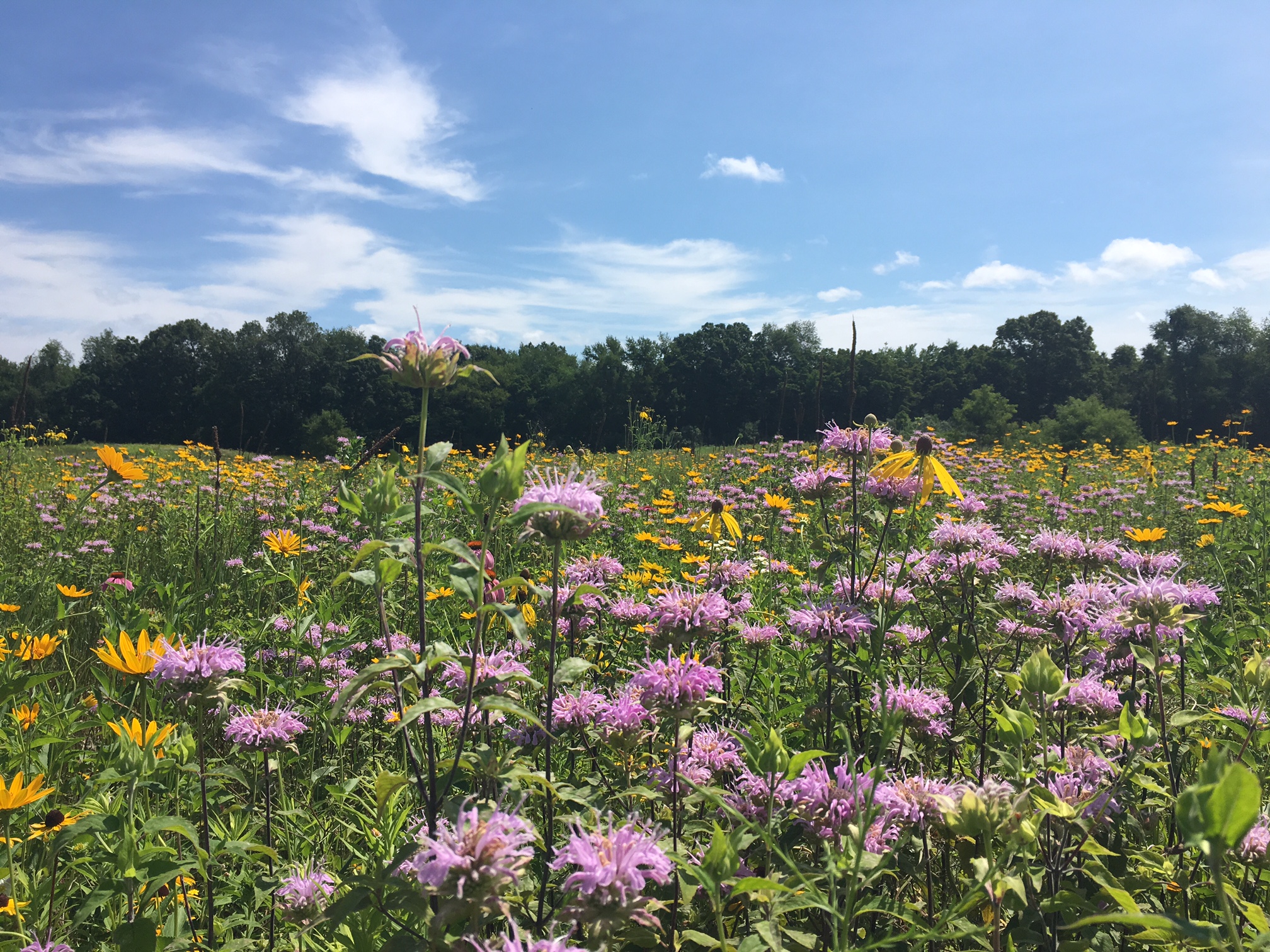
In Michigan, areas that used to be open prairie or park-like savannas are now densely forested, dramatically shrinking the living space for the thousands of plant, insect, bird and wildlife species that depend on open habitat types. Over time, the systems experience “mesophication”—a transition from a habitat of drier conditions, filled with more flammable fuels and tindery plants that carried fire to one that is moist and woody, more fire resistant, further precluding fire to the detriment of fire-adapted and fire-dependent species like wild lowbush blueberry and white oak.
Brian Stearns, an assistant fire management officer for the Forest Service working in the Huron-Manistee National Forests, has seen the shift happening during his tenure.
“Especially in the last 20 years, I feel like I’ve noticed the effects that that’s starting to have on the landscape, as far as mesophication, woody encroachment. We’re fighting harder to keep prairie and savanna systems open.”
Knowing where and how fire occurred in the past can help managers like Stearns better understand how best to apply prescribed fire—a kind of controlled fire administered by trained individuals—to restore those ecosystems. The information gleaned from the samples collected in the Manistee National Forest could shape how the Forest Service manages the forest today and in the future. Depending on the goals of a particular manager, the data can help inform which species should be planted, how frequently they should be managed with prescribed fire, how much risk there is for wildfire and how changes in climate might influence wildfire in the future.
In the Forest Service, every proposed burn must go through a process to ensure it meets the standards of the National Environmental Policy Act. Stearns uses dendrochronology research alongside other historical information to support the application of prescribed fire on certain parcels.
“I use that information to justify what we’re doing and why we’re doing it,” he said. “It’s a continuation of something that has probably occurred over the last 9,000 years.”
Members of the Lake States Fire Consortium are also working to synthesize regional fire history research into a handbook for land managers so they can apply the research in their planning.
. . .
The samples that Stambaugh and Dey collect are artifacts—of both ecology and culture. The information they contain will not only help land managers understand where to apply fire today, but they also fill in blanks in the historical record of people and their influence on the landscape before the earliest European settlers arrived. Beyond its applications in the Forest Service’s management of the Manistee National Forest, the data collected there will also contribute to a growing collection of tree-ring data spanning North America. On this scale, they can build a “pyrogeography” and begin to understand how people, climate and topography drove historical fire regimes.
Just as this research is being used to inform how land managers can best care for ecosystems, it could likewise be used to add details to existing knowledge of how Native Americans lived on the land. This connection is not lost on researcher Lane Johnson, who has worked on similar fire-scar dendrochronology studies in Minnesota.
“The colleagues that I’ve been working with, Evan Larson and Kurt Kipfmueller, we’ve been having conversations with tribal members that have ancestral ties to the places where we’ve been collecting fire history data,” Johnson said. “When we collect tree ring records of fire, it tells us the what, where and when in regard to fire history, but it doesn’t tell us the why. By engaging with tribal communities and tapping into their knowledge of place, their deep understanding of places they’ve been in for a long time, we can have this deeper and more nuanced understanding about the importance of fire in our landscapes over time.”
These collaborations can help give context to millennia of anthropogenic fire—but there is a limit on how much knowledge can be gleaned. A violent history of settlers forcing Native Americans to reservations has left many tribes disconnected from their ancestral lands and with a fragmented, albeit persistent, memory of how their ancestors specifically interacted with them.
“A lot of the very place-based specific knowledge, of traditional fire use, is just gone,” Johnson said. “We’re at this point where we’re needing to rebuild that knowledge. That can be done really collaboratively, and I think that’s another application of the tree-ring data.”
In Shelbyville, the Match-E-Be-Nash-She-Wish Band of Potawatomi Indians, or Gun Lake Tribe, has incorporated prescribed burning into its management of the lands it owns to restore prairie and pollinator habitat as well as a cultural connection to fire.
The Potawatomi are one of the tribes associated with the Three Fires Confederacy, along with the Ojibwe and the Odawa. The Anishinaabe alliance assigns each member tribe a role: the Ojibwe are the “keepers of the faith,” the Odawa the “keepers of trade” and the Potawatomi are the “keepers of the fire.”
“It’s really, really important—something that the Tribe as a whole, no matter which community you come from in the Potawatomi Nation, Potawatomi people really take that responsibility to heart and hold it in high regard,” said James “Bud” Day, language and culture director for the Gun Lake Tribe.
Day cited Tribal Elder Frank Barker as a source of much of his understanding of the Potawatomi’s relationship with fire. Historically, the Potawatomi used fire to cultivate their food resources, employing it to encourage the propagation of berries or attract wild game to an area for easy hunting. Today, the Gun Lake Tribe uses fire because it is an environmentally conscious way to support native plants and pollinators, prevent the spread of invasive species and preserve a cultural tradition. Though the locations of the lands the Tribe manages today aren’t where the Tribe would have historically burned—the Gun Lake area was a winter location for the Match-E-Be-Nash-She-Wish—connecting to the ways their ancestors interacted with and managed the landscape is important.
“A lot of our communities across this whole country are really grasping and really putting forth a very conscious effort to hit all of the ‘re’s’—and when I say ‘the re’s,’ I’m talking revitalization, restoration, resurgence, research, all of these different things of how we used to be,” Day said. “The more that we can recover and relearn—there’s a couple more ‘re’s’ for you—we can start to reuse those things and start to make them normal again.”
Johnson believes tree-ring research may be able to contribute to such efforts.
“(We can) link the place-based tree-ring records with the more general ideas about where and when and why people were burning, and for what resources. Suddenly it’s like, ‘Oh, these are our opportunities in these landscapes to restore fire as a process—both ecological and cultural,’” he said.
Respectful collaboration will be key.
“How do we do that in a way that’s respectful and not appropriating Indigenous perspectives? How do we make sure we’re doing that in a unified way, where we’re inviting them to come and being a part of those conversations from planning to implementation to monitoring—so that it’s healing for those communities and us as settler colonists, to be better stewards of place and to be more respectful of the trauma that’s occurred in those communities for a long time?” Johnson said.
. . .
Once Stambaugh and Dey haul their equipment and samples they’ve collected back to their SUV, they move to a site closer to Cadillac in hopes of finding more. Everything they collect will be analyzed alongside samples Guyette collected at a nearby site in Wolf Lake five years prior. Together, the samples will start to tell a more comprehensive story of how frequently, and how intensely, fire historically burned in this part of lower Michigan.
The pair conclude their time at the Wellston research site with a final sample from an enormous, weathered snag that lays on its side. The tree was likely uprooted by settlers who cleared the land of its vegetation by dragging chains across it. A toppled tree decays more slowly than one with its roots in the ground, preserving important data.
“Little did they know when they were chaining that they were creating fire history,” Stambaugh said.
“Saving it for me and you,” Dey said.
Disclosure: The author is employed by the Land Conservancy of West Michigan.
